deutsch english español


Participant: Stefan Roman
Perioada: 09 - 12 aprilie 2004
Zona: cordiliera andină din Chile şi Argentina, pasul Vergara
Distanţa: 210 km


Informaţii utile
Harta Paso Vergara


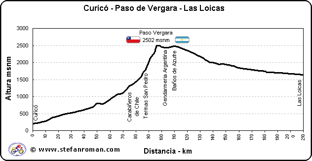
These altitude profiles are meant to serve bikers like an orientation by planning their trip over one of the most beatifull crossings of the Andes from Chile to Argentina. I have made this measurements during a bike tour in 2004. Altitude indications may vary ± 50 m due to atmospheric pressure change. Distances should be quite accurate. Always assure yourself that you carry enough food with yourself, as the region is very scarcly populated. You should have enough possibilities to find water.

Diese Höhenprofile sollen als Orientierung bei der Planung der Andenüberquerung von Chile nach Argentinien über den Vergara Pass helfen (VII Region - Provinz Mendoza). Diese Erhebungen habe ich während eine Fahrradtour 2003 gemacht. Höhenangaben haben wegen atmospherischen Druckveränderungen einen Tolleranzwert von ± 50 m. Die Distanzen sind ziemlich genau. Geht immer sicher dass ihr genügend Proviant dabeihabt, da die Gegend sehr dünn besiedelt ist. Wasser ist oft genug anzutreffen.

Estos perfiles de altura pudieran servir para la planificacion de una travesia en bicicleta de la cordillera de los Andes desde Chile a Argentina por el Paso Vergara (VII Region - Provincia de Mendoza). Hice estas medidas durante un viaje en 2003. Las indicaciones de las alturas podrian variar ± 50 m dado a cambios de presion atmosferica. Las distancias tendrian que tener una tolerancia minima. Asegurense siempre que tienen suficiente comida, dado que la region es muy poco poblada Agua van a encotrar en varios lugares.


Detaliile expediţiei cicloturistice Paso Vergara 2004


Dia

Fecha

Ruta

km/dia

km total

tiempo pedaleando

hh:mm

velocidad media

km/h

desnivel

m

subidos

m

bajados

m

altura maxima

m

1.

09.04.2004

Santiago-> Curicó - Romeral- Los Queñes - 10 km despues

54

54

4:15

12.6

799

692

107

794

2.

10.04.2004

- Termas San Pedro

32.9

86

3:45

8.7

1242

1098

144

1756

3.

11.04.2004

Termas San Pedro - Paso Vergara - (Θ ARG) Baños de Azufre - 3 km antes de campamento DNV

32.4

+ 18

118

3:35

9

1488

874

614

2502

4.

12.04.2004

- Las Loicas -> Malargue

73.4

192

5:04

14.4

1148

368

780

1983

5.

13.04.2004

Malargue -> Mendoza

6.

14.04.2004

Mendoza

7.

15.04.2004

Mendoza

8.

16.04.2004

Mendoza (Θ CHI)-> Santiago

Total 210 - 16:39 11.1 4677 3032 1645 -


Curicó - Las Loicas


Lugar / Pueblo Distancia Altura
Curicó 0 200
Romeral 10 275
Guaico I, II, III 15 380
cruze El Boldal 17.7 400
- 25.9 500
Camino de tierra 28.2 511
Puente Cardinal 36.7 580
Los Queñes 42.2 644
- 47.2 700
- 50 790
- 54 777
- 55 800
Quebrada de la mujer 59.5 900
- 63.2 1000
Pte. Infernillo 65.4 1060
- 70.2 1100
Cruce Mina de Fierro 74.2 1280
- 74.8 1300
Baños Escondido 79.5 1400
Reten Carabiñeros 81 1450
- 82.5 1500
- 84.3 1600
- 85.5 1700
Termas San Pedro 86.9 1750
- 88.3 1840
- 89.2 1940
- 90.3 2040
- 91.5 2140
- 93.7 2240
Zeltplatz 94.4 2290
- 94.9 2340
plat 95.9 2472
Limite Chile - Argentina 96.6 2493
- 98.4 2490
- 100.1 2452
Gendarmeria Argentina 105.2 2440
Baños de Azufre 112.4 2470
- 129.9 2180
- 136.9 2008
Campamento DNV 139.9 1998
- 144.9 1940
- 145.9 1960
Arroyo El Relvo 147.4 1950
Arroyo El Montañes 156.7 1878
Doña Angela 159.9 1840
Arroyo El Seguro 170.9 1780
- 180.1 1740
Mallines Colgados 182.4 1715
Invernadero del Viejo 191.9 1690
Las Loicas 210.2 1640
 

These graphics and data are intended for private use. Any commercial use is prohibited without written permission by the author.

Diese Graphiken und Daten sind für den privaten Gebrauch. Jedwelche kommerzielle Nutzung ist ohne die schriftliche Erlaubnis des Authors untersagt.

Estos graficos y datos son para uso privado. Cualquir uso comercial esta prohibido sin la permision escrita del autor.


© www.stefanroman.com 2001 - 2009
vizitatori